Monday, January 23, 2012

Mount Apo (2,954 m), the highest point in the Philippines

Mount Apo - Philippines' Highest Peak
Mount Apo is a large solfataric, potentially-active stratovolcano in the island of Mindanao, Philippines. With an altitude of 2,954 metres (9,692 ft), it is the highest mountain in the country and is located between Davao City and Davao del Sur province in Region XI and Cotabato province in Region XII. The peak overlooks Davao City 40 kilometres (25 mi) to the northeast, Digos City 25 kilometres (16 mi) to the southeast, and Kidapawan City 20 kilometres (12 mi) to the west.

Apo, which means "ancestor", is flat-topped mountain with three peaks and is capped by a 500-metre-wide (1,600 ft) volcanic crater containing a small crater lake. The date of its most recent eruption is unknown, and none are verified in historical times.

The volcano is one of the most popular climbing destinations in the Philippines with the summit, on the average, takes two days to reach. The first recorded climb was on October 10, 1880, by a party led by Joaquin Rajal, then Spanish governor of Davao.

Conservation

Mount Apo Natural Park

On May 9, 1936, Mount Apo was declared a national park with Proclamation no. 59 by President Manuel L. Quezon, followed by Proclamation no. 35 of May 8, 1966 then Proclamation no. 882 of September 24, 1996. On February 3, 2004, the approval of Republic Act no. 9237 established Mount Apo as a protected area under the category of natural park with an area of 54,974.87 hectares (135,845.9 acres); with two peripheral areas of 2,571.73 hectares (6,354.9 acres) and 6,506.40 hectares (16,077.7 acres) as buffer zones, provided for its management and for other purposes.

Although a declared a Natural Park, the current climbing trails are littered with rubbish by irresponsible climbers, opening paths for soil erosion across the already denuded mountain sides. Some mountain and social climbing groups conduct climbs after the Holy Week/Easter, the peak climbing season, to clean the affected areas.


UNESCO World Heritage list

The Department of Environment and Natural Resources (DENR) submitted Mount Apo on December 12, 2009 for inclusion in the UNESCO world heritage list. The mountain is considered by DENR as the center of endemism in Mindanao. It has one of the highest land-based biological diversity in terms of flora and fauna per unit area. It has three distinct forest formations, from lowland tropical rainforest, to mid-mountain forests, and finally to high mountain forests.

A portion of the eastern slopes are also within the scope of the UNESCO Hydrology Environment Life and Policy (HELP) Network. The Davao HELP Network is focused on building collaboration among watershed stakeholders.

Flora and Fauna

The mountain is home to over 272 bird species, 111 of which are endemic to the area. It is also home to one of the world's largest eagles, the Philippine Eagle, which is the country’s national bird.

Fruits like durian, the king of fruits, grow abundantly in Mt. Apo.


Geothermal energy

Mount Apo is an excellent source of geothermal energy. Located in Barangay Ilomavis, Kidapawan City, North Cotabato is the Mindanao Geothermal Production Field with a power output of 106 MW, currently the only power plant of its kind in Mindanao.

The Philippine National Oil Company geothermal plant supplies electricity to Kidapawan and its neighboring provinces, its completion boosted the city's economy.

Indigenous peoples

Six indigenous peoples - Manobos, Bagobo, Ubos, Atas, K’Iagans and the Tagacaolo consider Mt. Apo as their ancestral domain and their home. These tribes have lived since time immemorial, around the mountain that they also consider as sacred ground, their place of worship and burial ground of Apo Sandawa, their great forefather. A number of genealogies of known Lumad leaders in South Central Mindanao trace their roots to Mt. Apo. For the Lumads, the term Apo was coined from the name of their great grandparent Apo Sandawa. Mt. Apo is the source of their continual supply of food and medicine, their spiritual and cultural way of life.

Hiking activity

At 2,954 meters (9,692 ft), Mount Apo is the highest mountain in the Philippines. This majestic peak is one of the country's most popular climbing destinations.

Several trails lead to the summit, coming from North Cotabato and Davao provinces. Arguably the easiest route to the National Park is through Kidapawan City with an average hike taking 3–4 days roundtrip. In the classification system used by local popular mountaineering website PinoyMountaineer.com, the difficulty of the hike is 7 out of 9. Various sights along the trail include Lake Venado, one of the highest lakes in the Philippines, the solfataras and the old crater near its summit. The mountain may be climbed year-round or one can register and join the city's Summer Climb or the Annual October Trek / Climb.

Mount Ramelau (2,963 m), the highest mountain in East Timor

Tatamailau (Tetum: Foho Tatamailau), sometimes referred as Mount Ramelau, is the highest mountain in East Timor and also of Timor island at 2,963 m (9,721 ft). The mountain is located approximately 70 km (43 mi) of the capital Dili in the district of Ainaro. In Portuguese colonial days it was considered the highest mountain of Portugal, and indeed of the whole Portuguese colonial empire, since the highest mountain of Portugal is of a more modest height. The name "Tatamailau" is Mambai-origin, the local language and means "Grandfather of all". "Ramelau" is the name of the massif of the mountain. The Tatamailau is dedicated to the Virgin Mary and the subject of an annual pilgrimage commemorating the Annunciation of the Blessed Virgin Mary, on or around March 25. There is a three meter high statue of the Virgin Mary on the peak, which came from Italy and was erected during the Indonesian rule in 1997.

Tatamailau can be climbed from the town of Hato Bulico 3 km (1.9 mi) to the northeast or from the village of Aimeta 6 km (3.7 mi) to the north; there is about 910 m (2,990 ft) of climbing from either. The track from Hato Bulico to the summit is very well formed having originally been cut to create a pilgrimage trail to the Virgin Mary figure on the summit and was once negotiable by four wheel drive vehicle. A map is not required once on the track. The track is now very severely degraded with massive washouts requiring major detours to negotiate. Because the track was cut for vehicular access the constant gradient is monotonous, the poor engineering has caused major environmental damage and the route affords few views of note. The route from Aimeta is via a network of goat herders' tracks, it does not appear on current maps and a local guide is needed. However, the Aimeta track is varied, traverses unspoilt country, is extremely interesting with many unfolding mountain views and consequently presents by far the most enjoyable climb. A fit person should allow four hours from Hato Bulico to the summit, six hours from Aimeta, nine hours from Aimeta to Hato Bulico. Assume no water is available en route. There is no human habitation above Hato Bulico or Aimeta. It is possible to camp on the saddle below the summit in the dry season and experience the sunset and sunrise from the same location. The summit can freeze in the dry season; in the wet season the summit can be sufficiently cold, wet and windy to pose a risk of hypothermia.


Hato Bulico is a 1½ - 2 hour drive from Maubisse on a sealed road but requires a four wheel drive. In the wet season it can be dangerous and periodically impassable but never for long. There is an excellent resting place at Hato Bulico close to the start of the track.

Aimeta can be reached from Letefoho in about 1½ hours. Shelter, but not food, may be negotiated at Aimeta with local assistance but it is advisable to arrive entirely self sufficient. The nearest accommodation is at the Saint Bakhita, Eraulo, via Vila Ermera and an excellent, easy walk is to be had from there to Aimeta in about four hours. Horses for baggage can be hired at Aimeta and this is useful if camping on the summit or to assist stragglers. Aimeta can be a logistical challenge, which is why almost all summit bids are launched from Hato Bulico but it is possible, with care, for supporting transport to drive from Aimeta directly to Hato Bulico if the road is navigable otherwise, in the Wet season, via Gleno and Aileu in about five hours. An ideal route is to do the summit from Aimeta to Hato Bulico taking in both sides of the mountain; local assistance is essential for those without fluent Tetum and local knowledge.

Sunday, January 22, 2012

Mount Kinabalu (4,093 m) the highest mountain of Malaysia and Borneo

Mountain Kinabalu
Mount Kinabalu (Malay: Gunung Kinabalu) is a prominent mountain on the island of Borneo in Southeast Asia. It is located in the East Malaysian state of Sabah and is protected as Kinabalu National Park, a World Heritage Site. Kinabalu is the tallest peak in Borneo's Crocker Range and is the tallest mountain in the Malay Archipelago. Mount Kinabalu is also the 20th most prominent mountain in the world by topographic prominence.

In 1997, a re-survey using satellite technology established its summit (known as Low’s Peak) height at 4,095 metres (13,435 ft) above sea level, which is some 6 metres (20 ft) less than the previously thought and hitherto published figure of 4,101 metres (13,455 ft).

Mount Kinabalu includes the Kinabalu montane alpine meadows ecoregion in the montane grasslands and shrublands biome. The mountain and its surroundings are among the most important biological sites in the world, with over 4500 species of plant, 326 species of birds, and 100 mammalian species identified. Among this rich collection of wildlife are famous species such as the gigantic Rafflesia plants and the orangutan. Mount Kinabalu has been accorded UNESCO World Heritage status.

Low's Peak can be climbed quite easily by a person in good physical condition and there is no need for mountaineering equipment at any point on the main route. Other peaks along the massif, however, require rock climbing skills.

Biology

Significantly, Mount Kinabalu along with other upland areas of the Crocker Range is well-known worldwide for its tremendous botanical and biological species biodiversity with plants of Himalayan, Australasian, and Indomalayan origin. A recent botanical survey of the mountain estimated a staggering 5,000 to 6,000 plant species (excluding mosses and liverworts but including ferns), which is more than all of Europe and North America (excluding tropical regions of Mexico) combined. It is therefore one of the world's most important biological sites.

Large lower pitcher of Nepenthes rajah

Flora

The flora covers the mountain in zones of different types of habitat as one climbs up, beginning with a lowland belt of fig trees and insectivorous pitcher plants. Then between 2,600 to 3,200 m (8,530 to 10,499 ft) is a layer of short trees such the conifer Dacrydium gibbsiae and dwarf shrubs, mosses, lichens, liverworts, and ferns. Finally many of the world's richest variety of orchids are found on the high rockier slopes.

These plants have high levels of endemism (i.e. species which are found only within Kinabalu Park and are not found anywhere else in the world). The orchids are the best-known example with over 800 species including some of the highly-valued Paphiopedilum slipper orchids, but there are also over 600 species of ferns (more than the whole of Africa’s 500 species) of which 50 are found nowhere else, and the richest collection in the world for the Nepenthes pitcher plants (five of the thirteen are found nowhere else on earth) which reach spectacular proportions (the largest-pitchered in the world being the endemic Nepenthes rajah). The parasitic Rafflesia plant, which has the largest single flower in the world, is also found in Kinabalu (particularly Rafflesia keithii whose flower grows to 94 centimetres (37 in) in diameter), though it should be noted that blooms of the flower are rare and difficult to find. Meanwhile another Rafflesia species, Rafflesia tengku-adlinii, can be found on the neighbouring Mount Trus Madi and the nearby Maliau Basin.

Its incredible biodiversity in plant life is due to a combination of several unique factors: its setting in one of the richest plant regions of the world (the tropical biogeographical region known as western Malesia which comprises the island of Sumatra, the Malay Peninsula, and the island of Borneo), the fact that the mountain covers a wide climatic range from near sea level to freezing ground conditions near the summit, the jagged terrain and diversity of rocks and soils, the high levels of rainfall (averaging about 2,700 millimetres (110 in) a year at park HQ), and the climatic instability caused by periods of glaciation and catastrophic droughts which result in evolution and speciation. This diversity is greatest in the lowland regions (consisting of lowland dipterocarp forests, so called because the tree family Dipterocarpaceae are dominant). However, most of Kinabalu’s endemic species are found in the mountain forests, particularly on ultramafic soils (i.e. soils which are low in phosphates and high in iron and metals poisonous to many plants; this high toxic content gave rise to the development of distinctive plant species found nowhere else).

A mountain squirrel, probably Sundasciurus tenuis, from Mount Kinabalu

Fauna

The variety of plant life is also habitat for a great variety of birds and animals. There are some 326 species of birds in Kinabalu Park, including the spectacular Rhinoceros Hornbill, Mountain Serpent-eagle, Dulit Frogmouth, Eyebrowed Jungle Flycatcher, and Bare-headed Laughingthrush. Twenty-four birds are mainly found on the mountain and one, the Bornean Spiderhunter, is a pure endemic. The mountain is home to some 100 mammalian species mostly living high in th trees, including one of the four great apes, the orangutan (though sightings of these are uncommon; estimates of its numbers in the park range from 25 to 120). Other mammals include three kinds of deer, the Malayan Weasel (Mustela nudipes), Oriental Small-clawed Otter (Aonyx cinerea), and Leopard Cat (Felis bengalensis). Endemic mammals include the Black Shrew (Suncus ater) and Bornean Ferret-badger (Melogale everetti).

Endemic annelids number less than a dozen known species but include the Kinabalu giant red leech that preys on various earthworms, including the Kinabalu giant earthworm.

Threats and preservation

The steep mountainsides with poor soil are not suitable for farming or for the timber industry so the habitats and animal life of Kinabalu remain largely intact, with about a third of the original habitat now degraded. Kinabalu Park was established in 1964 and the nearby mountains were protected as the Crocker Range National Park in 1984. However even national park status does not guarantee full protection, as logging permits were granted on Trus Madi in 1984.

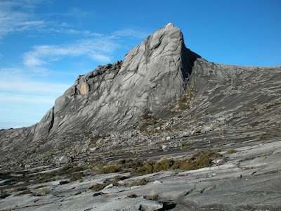
Summit of Mount Kinabalu

Geology

Mount Kinabalu is essentially a massive pluton formed from granodiorite which is intrusive into sedimentary and ultrabasic rocks, and forms the central part, or core, of the Kinabalu massif. The granodiorite is intrusive into strongly folded strata, probably of Eocene to Miocene age, and associated ultrabasic and basic igneous rocks. It was pushed up from the earth’s crust as molten rock millions of years ago. In geological terms, it is a very young mountain as the granodiorite cooled and hardened only about 10 million years ago. The present landform is considered to be a mid-Pliocene peneplain, arched and deeply dissected, through which the Kinabalu granodiorite body has risen in isostatic adjustment. It is still pushing up at the rate of 5 mm per annum. During the Pleistocene Epoch of about 100,000 years ago, the massive mountain was covered by huge sheets of ice and glaciers which flowed down its slopes, scouring its surface in the process and creating the 1,800 metres (5,900 ft) deep Low's Gully (named after Hugh Low) on its north side. Its granite composition and the glacial formative processes are readily apparent when viewing its craggy rocky peaks.

History

British colonial administrator Hugh Low made the first recorded ascent of Mount Kinabalu's summit plateau in March 1851. Low did not scale the mountain's highest peak, however, considering it "inaccessible to any but winged animals". In April and July 1858, Low was accompanied on two further ascents by Spenser St. John, the British Consul in Brunei. The highest point of Mount Kinabalu was finally reached in 1888 by zoologist John Whitehead. British botanist Lilian Gibbs became the first woman and the first botanist to summit Mount Kinabalu in February 1910.

Botanist E. J. H. Corner led two important expeditions of the Royal Society of Great Britain to the mountain in 1961 and 1964. Kinabalu National Park was established in 1964. The park was designated a natural World Heritage Site in 2000.


Climbing route

Climbers must be accompanied by accredited guides at all times due to national park regulations. There are two main starting points for the climb: the Timpohon Gate (located 5.5 km from Kinabalu Park Headquarters, at an altitude of 1,866 metres (6,122 ft)), and the Mesilau Nature Resort. The latter starting point is slightly higher in elevation, but crosses a ridge, adding about two kilometres to the ascent and making the total elevation gain slightly higher. The two trails meet about two kilometres before Laban Rata.

Accommodation is available inside the park or outside near the headquarters. Sabah Parks has privatized Mount Kinabalu activities to an organization called Sutera Sanctuary Lodges (also known as Sutera Harbour). The mountain may be climbed on a single day drip, or hikers may (usually) stay one night at Laban Rata Resthouse at 3,270 metres (10,730 ft) in order to complete the climb in 2 days, finishing the ascent and descending on the second day. The majority of climbers begin the ascent on day one of a two day hike from Timpohon gate at 1,866 metres (6,122 ft), reaching this location either by minibus or by walking, and then walk to Laban Rata. Most people accomplish this part of the climb in 3 to 6 hours. Since there are no roads, the supplies for the Laban Rata Resthouse are carried by porters, who bring up to 30 kilograms of supplies on their backs. Hot food and beverages, hot showers and heated rooms are available at Laban Rata. The last 2 kilometres (6,600 ft), from the Laban Rata Resthouse at 3,270 metres (10,730 ft) to Low's Peak (summit) at 4,095.2 metres (13,436 ft), takes between 2 and 4 hours. The last part of the climb is on naked granite rock.

Given the high altitude, some people may suffer from altitude sickness and should return immediately to the bottom of the mountain, as breathing and any further movement becomes increasingly difficult.

Tales

There are two stories that led to the main beliefs in the origin of the mountain's name.

The first derivation of the word Kinabalu is extracted from the short form for the Kadazan Dusun word 'Aki Nabalu', meaning "the revered place of the dead".

The second source states that the name "Kinabalu" actually means "Cina Balu" (which would fully mean "A Chinese Widow"). Due to the lingual influence among the Kadazan Dusun of Sabah, the pronunciation for the word "cina" (chee-na) was changed to "Kina" (kee-na).

It was told that a Chinese prince, was cast away to Borneo when his ship sank in the middle of the South China Sea. He was subsequently rescued by the natives from a nearby village. As he recovered, he was slowly accepted as one of the people of the village. Eventually, he fell in love with a local woman, and married her. Years went by, and he started to feel homesick. So he asked permission from his newly-found family to go back to China to visit his parents (the Emperor and Empress of China). To his wife, he promised that as soon as he was done with his family duties in China, he would come back to Borneo to take her and their children back to China.

When he made his return to China, he was given a grand welcome by his family. However, to his dismay, his parents disagreed with him about taking his Bornean wife back to China. Worse, they told him that he was already betrothed to a princess of a neighbouring kingdom. Having no choice (due to high respect towards his parents), he obeyed with a heavy heart.

Meanwhile, back in Borneo, his wife grew more and more anxious. Eventually, she decided that she will wait for her husband's ship. However, since the village was situated far away from the coast, she couldn't afford to come to the shore and wait for him daily. Instead she decided to climb to the top of the highest mountain near her village, so that she could have a better view of the ships sailing in the South China Sea. Thus, she was then seen climbing up the mountain at every sunrise, returning only at night to attend to her growing children.

Eventually her efforts took their toll. She fell ill, and died at the top of the cold mountain while waiting for her husband. The spirit of the mountain, having observed her for years, was extremely touched by her loyalty towards her husband. Out of admiration for this woman, the spirit of the mountain turned her into a stone. Her face was made to face the South China Sea, so that she could wait forever for her dear husband's return.

The people in her hometown who heard about this were also gravely touched by this. Thus, they decided to name the mountain "Kinabalu" in remembrance of her. To them, the mountain is a symbol of the everlasting love and loyalty that should be taken as a good example by women.

Local legend among the people of Ranau, a district in Sabah, has it that St. John's Peak was the stone which her body was turned into.

A panoramic view from the summit of Mount Kinabalu

Friday, January 20, 2012

Hkakabo Razi (5,881 m), the highest peak in Myanmar and South East Asia

Hkakabo Razi is Southeast Asia's highest mountain, located in the northern Myanmar state of Kachin. It lies in an outlying subrange of the Greater Himalayan mountain system. The mountain lies on the border tri-point among Myanmar, China, and India.

The peak is enclosed within Hkakabo Razi National Park. The park is entirely mountainous and is characterized by broad-leaved evergreen rain forest, a sub-tropical temperate zone from 2,438 to 2,743 metres (7,999–8,999 ft), then broad-leaved, semi-deciduous forest and finally needle-leaved evergreen, snow forest. Above 3,353 metres (11,001 ft), the highest forest zone is alpine, different not only in kind from the forest, but different in history and origin. Still higher up, around 4,572 metres (15,000 ft), cold, barren, windswept terrain and permanent snow and glaciers dominate. At around 5,334 metres (17,500 ft), there is a large ice cap with several outlet glaciers.

Environmental protection

Hkakabo Razi was established as a natural reserve on January 30, 1996 and as a national park on November 10, 1998. The Khakaborazi National Park is the last stronghold for biodiversity in Myanmar. Extraordinarily rich flora and fauna, ranging from lowland tropical to alpine species still await proper research and identification. They have barely been studied, and the park remains an excellent center for field study for students of botany, geology, zoology and geography. A study was done by the Forest Department with the assistance of Wildlife Conservation Society of New York during 1997 and 1998. The results have been presented in ICIMOD sponsored Workshop “Sub-regional Consultation on Conservation of Hkakabo Razi Mountain Ecosystems in Eastern Himalayas”, held in Putao, Myanmar during 25–29 October 1999. This was followed in 2001 with an international, interdisciplinary team of scientists from the California Academy of Sciences in San Francisco, National Geographic Society, Harvard University, the Chinese Academy of Sciences, and the Myanmar Forestry Ministry. On 11 September 2001, herpetologist Joseph Slowinski, team leader from California Academy of Sciences, was bitten by a venoumous krait and died in the field. In 2002-2003, P. Christiaan Klieger, anthropologist from California Academy of Sciences and photographer Dong Lin retraced their previous steps, and succeeded in making the first anthropological survey of the Hkakabo Razi region. On foot they reached the northern-most village in Myanmar , Tahaundam, which is inhabited by about 200 Khampa Tibetans, including mountaineer Nyama Gyaltsen.

The region will shortly be opened to the general public through eco-tourism by the Myanmar authorities. The government is collecting information for development in that regard and a number of scientific expeditions have been already accepted in the region.

Only a few Westerners ever made it to Mt. Hkakabo Razi, the National Park or anywhere close to it. Historically, Lord Cranbrook and Richard Kaulback probably have been the first westeners to walk through the Alung Dung valley.


Climbing information

Takashi Ozaki (Japan, 1951-May 14, 2011) and Nyima Gyaltsen (aka "Aung Tse"; Burma) made the first ascent in 1996. Ozaki had attempted the mountain in 1995 but was turned back due to bad weather. Ozaki died May 14, 2011 while attempting to summit Mt. Everest. The route to basecamp is long (four weeks) and arduous through dense rain forest with many unbridged stream crossings. The recent first ascent can also be attributed to the policy that foreigners were not allowed into the area until 1993.

Sunday, January 15, 2012

Kuduremukh (1,894m)

Kudremukh also spelled Kuduremukha is a mountain range in Chikkamagaluru district, in Karnataka, India. It is also the name of a small hill station town situated near the mountain, about 48 kilometers from Karkala and about 20 kilometers from Kalasa. The name Kuduremukha (as it is known by the natives) literally means 'horse-face' (in the local language Kannada) and refers to a particular picturesque view of a side of the mountain that resembles the same. It was also referred to as 'Samseparvata', historically since it was approached from Samse village.

The town of Kudremukh is primarily an iron ore mining town where the government run Public Sector Kudremukh Iron Ore Company Ltd. (KIOCL) operated till the last decade. It is noted for its scenic beauty. Owing to the dense forests, sighting wildlife can be challenging, though the area is rich in wildlife. Nonetheless the drive through the forest ranges can be enchanting and exhilarating. Three important rivers, the Tunga, the Bhadra and the Nethravathi are said to have their origin here. A shrine of goddess Bhagavathi and a Varaha image, 1.8 m within a cave are the main attractions.

The Tunga river and Bhadra river flow freely through the parklands. Kadambi waterfalls area definite point of interest for anyone who travels to the spot. The animals found there include the malabar civet, wild dogs, sloth bear and spotted deer.

Recently, it is declared a Tiger Reserve, falling under the Bhadra Tiger Sanctuary Umbrella. It was declared by the honourable Union Environmental Minister, Mr.Jairam Ramesh.

Location

The Kudremukh National Park (latitudinal range 13°01'00" to 13°29'17" N, longitudinal range 75°00'55' to 75°25'00" E) is the second largest declared Wildlife Protected Area (600.32 km²) of a tropical wet evergreen type of forest in the Western Ghats. Kudremukh National Park is located in Dakshina kannada and Chikkamagaluru districts of Karnataka states. The Western Ghats is one of the thirty four hot spots identified for bio-diversity conservation in the world. Kudremukh National Park comes under the Global Tiger Conservation Priority-I, under the format developed jointly by Wildlife Conservation Society (WCS) and World Wide Fund-USA.


Geography

The southern and western sides of the park form the steep slope of the Western Ghat ridge line, with the altitude varying from 100 m - 1892 m (peak). The northern, central and the eastern portions of the park form a chain of rolling hills with a mosaic of natural grassland and shola forest. Kudremukh receives an average annual rainfall of 7000 mm, which has evolved forest types of mainly evergreen vegetation.

History

The British Government declared Kudremukh region as a Reserved Forest in 1916, to stop rampant slash and burn cultivation practices from penetrating deeper into the Ghats. Well known environmentalist and Tiger expert Dr. Ullas Karanth, undertook a detailed and systematic survey of the distribution of the endangered Lion Tailed Macaque in Karnataka during 1983-84 with support from Government of Karnataka. He observed that suitable and extensive rainforest habitat for Lion-tailed Macaque existed in Kudremukh and that the tract probably harbored the largest contiguous population of lion tailed macaques in the Western Ghats outside the Malabar region. He further suggested that Lion Tailed Macaques could be effectively used as a 'flagship' species to conserve the entire biotic community in the region and prepared a conservation plan for survival of wild population of Lion Tailed Macaques in the region delineating the present national park area as a proposed nature reserve. Based on his report, the Karnataka State Wildlife Advisory Board suggested to the Government that Kudremukh National Park be created. Subsequently, the first notification of the Kudremukh National Park was issued. In 1987, the Government of Karnataka declared these Reserved Forests as a National Park based on the above suggestion.

Demographics

As of 2001 India census, Kudremukh had a population of 8095. Males constitute 54% of the population and females 46%. Kudremukh has an average literacy rate of 80%, higher than the national average of 59.5%: male literacy is 83%, and female literacy is 77%. In Kudremukh, 11% of the population is under 6 years of age.

Ecology

A diverse assemblage of endangered large mammals is found in the park supporting three large mammal predator species Tiger, Leopard and Wild Dogs. The important Tiger prey base found within the Park is Gaur, Sambar, Wild Pig, Muntjac, Chevrotain, Bonnet Macaque, Common Langur and the Lion Tailed Macaque.

The wet climate and the tremendous water retentive capacity of the shola grasslands and forests has led to the formation of thousands of perennial streams in the region converging to form three major rivers of the region, Tunga, Bhadra and Nethravathi that form an important lifeline for the people of Karnataka and Andhra Pradesh. Lobo house is an old abandoned house on top of Kuduremukha.


Hanumana Gundi Waterfalls

Located 32 km (20 mi) from the Kalasa, the water fall has water falling onto Natural rock formations from a height of more than 100 feet (30 m). Getting into falls involves some trekking. The best time to visit this place is between October and May.

Trekking in Kudremukh

There are about 13 trekking routes in Kudremukh ranging from easy to tough. The most know ones among them are:
  1. Samse - Kudremukh - Samse. The duration fro this trek is around 4 days and 3 nights, covering a total distance of about 40 plus km.
  2. Navoor - Hevala - Kudremukh - Navoor. The duration fro this trek is around 5 days and 4 nights, covering a total distance of about 60 plus km.
  3. Navoor - Kudremukh - Samse. The duration fro this trek is around 5 days and 4 nights, covering a total distance of about 50 plus km.
  4. Horanaadu - Sringeri. The duration fro this trek is around 3 days and 2 nights, covering a total distance of about 30 plus km.

Threats

Kudremukh Iron Ore Company Limited (KIOCL) is a government run company which was mining iron ore from the Kudremukh hills. KIOCL conducted its operations on an area of 4,604.55 ha for over 20 years. Opposition to its activities built up over the years from environmentalists and wildlife conservationists who are concerned about the threat to the region's flora and fauna, and farmers who are affected by the pollution of the streams that originate in the mining area. KIOCL has been banned from operating in this beautiful Natural Reserve, according to Supreme court order.

The rainfall in Kuduremukh, which is perhaps one of the highest for any open cast mining operation in the world, greatly accentuates the impacts of siltation as claimed by environmentalists. The topographic and rainfall characteristics in combination with the open cast mining of low grade iron ore and other land-surface disturbances caused by the KIOCL operations resulted in very high sediment discharge, with over 60% of the total siltation in the Bhadra system being contributed by the mining area which forms less than six per cent of the catchment. With high quality practices adopted by KIOCL to mine, the flora and fauna remained intact, causing no adverse affects on the nature.

KIOCL used to send iron ore through pipes running through districts of Udupi and Dakshina Kannada and converted to pellets at their plant in Panambur.These pellets were exported to countries like China, Iran, Japan, etc. by ships.

Wednesday, January 4, 2012

Chembra Peak (2,100m)

Chembra Peak is the highest peak in Wayanad, at 2,100 metres (6,900 ft) above sea level. Chembra is located near the town of Meppady and is 8 km south of Kalpetta. It is part of the Wayanad hill ranges in Western Ghats, adjoining the Nilgiri Hills in Tamilnadu and Vellarimala in Kozhikode district in Kerala. Chembra peak is accessible by foot from Meppady. District Tourism Promotion Council provides guides and trekking equipments on hire charges to the tourists. Permission from the forest office in Meppady is required for trekking up to Chembra Peak. A heart shaped lake on the way to the top of the peak is a major tourist attraction. The lake is believed to have never dried up. You can find the lake half way to the peak, after getting to the lake you need to trek another half way which is through the dense trees of about one to two km. A 5 km journey from Meppadi town through tea estates to Erumakkolli.

Transportation

One can reach the forest office, from where a pass has to be acquired to trek the mountain. Also services of guide can be availed which might be very useful. The trek to the top takes 3 hours, and one can see almost the whole of Wayanad and parts of Malappuram, Kozhikkode and Nilgiri districts.


Chembra is located in Meppadi (Meppady) Panchayath, 11 km off NH212 (Kollegal - Mysore - Kozhikode). For people who prefer public transport, KSRTC (both Kerala & Karnataka) and a lot of private companies operate overnight deluxe buses between Kozhikode (aka Calicut) and Bengaluru. People taking buses can get down at Kalpetta and catch another bus to Meppadi. Meppadi is 11 km from Chundale, in the SH29, connecting Chundale to Ooty.

Anamudi (2,675 m), highest point of peninsular India

Anamudi is located in the Indian state Kerala. It is the highest peak in the Western Ghats and South India, at an elevation of 2,695 metres (8,842 ft), and a topographic prominence of 2,479 metres (8,133 ft). The name Anamudi literally translates to "elephants forehead," a reference to the resemblance of the mountain to an elephant's head.

The first recorded ascent of the Anamudi was by General Douglas Hamilton of the Madras Army on May 4, 1862, but it is likely that there had been earlier ascents by local people.

Climatic zones and biomes

Anamudi is the highest peak in the Western Ghats in India, having an elevation of 2,695 metres (8,842 ft). Anamudi is also the highest point in South India, and also the highest point in India outside the Himalaya-Karakoram mountain range. This gives Anamudi its relatively large topographic prominence of 2,479 metres (8,133 ft), the associated key saddle being 2,000 kilometres (1,200 mi) away at 28°35′20″N 76°27′59″E.

The peak is not exceptionally dramatic in terms of steepness or local relief and is a Fault-block mountain. It is located in the southern region of Eravikulam National Park at the junction of the Cardamom Hills, the Anamala Hills and the Palni Hills. The nearest town is Munnar, 13 kilometres (8.1 mi). The easiest route to the summit of Anamudi is a technically easy hike on grass slopes, starting from a rolling hill plateau with a base elevation of about 2,000 metres (6,600 ft). The north and south slopes are gentle, while the east and west slopes are steeper, with more difficult rock faces. The heavy evergreen forests are present with bamboos, black-wood (Dalbergia latifolia), and teak growing in abundance. The heavy forest with which the range is clothed is the source of the most valuable of the rivers which traverse the drier country to the east, namely the Vaigai, and Thamirabarani ; and the waters of the Periyar, which flows into the Arabian Sea.


Anamudi and the Eravikulam National Park surrounding it is home to the largest surviving population of the Nilgiri Tahr(Nilgiritragus hylocrius). Asian Elephants, Gaur, Bengal tigers, and the Nilgiri Marten (Martes gwatkinsii) are some of the species of animals found here. The summit of the Anamudi is vegetated with patches of stunted Arundinaria densifolia and Gaultheria fragrantissima (wintergreen), Anaphalis sp., Impatiens and some species of Eriocaulon.

 
Design by | Bloggerized by World Mountain - Premium Blogger Themes | Blogger Templates