Showing posts with label Eight Thousanders Of Himalaya. Show all posts

Saturday, June 4, 2011

Notable ascents and attempts Of Shishapangma


  • 1980 7 May, "Northern Route", (2nd ascent) by Michl Dacher, Wolfgang Schaffert, Gunter Sturm and Fritz Zintl; Sigi Hupfauer and Manfred Sturm (12 May); as part of a German expedition.
  • 1980: 13 October, "Northern Route", (3rd ascent) by Ewald Putz and Egon Obojes, as part of an Austrian expedition.
  • 1981: 30 April, "Northern Route", (4th ascent) by Junko Tabei, Rinzing Phinzo and Gyalbu Jiabu, as part of a Japanese women's expedition.
  • 1981: 28 May, "Northern Route", (5th ascent) by Reinhold Messner and Friedl Mutschlechner, as part of an Austrian expedition.
  • 1982: 28 May, "British Route", southwest face (alpine style), FA by Doug Scott, Alex Macintyre and Roger Baxter-Jones (all UK). Route follows the right-hand couloir on the southwest face.
  • 1987: 18 July, Elsa Ávila and Carlos Carsolio become the first Mexicans to summit Shishapangma. For Ávila, her first eight-thousander and for Carsolio, his second, via the northern face/ridge to the central summit, then along the arete to the main summit, with Wanda Rutkiewicz, Ramiro Navarrete, and Ryszard Warecki.
  • 1987: 18 September, west ridge, FA by Jerzy Kukuczka and Artur Hajzer (both Poland). Kukuczka skied down from near the summit on this his fourteenth eight-thousander.
  • 1987: 19 September, central couloir, north face, FA by Alan Hinkes (UK) and Steve Untch (USA).
  • 1989: Central buttress, southwest face, Andrej Stemfelj and Pavle Kozjek.
  • 1990: Left-hand couloir, southwest face, Wojciech Kurtyka (Poland), Erhard Loretan (Switzerland) and Jean Troillet (France)
  • 1993: Far-right couloir, southwest face, solo by Krzysztof Wielicki (Poland).

  • 2002: 5 May, "Korean Route" on southwest face, Park Jun Hun and Kang Yeon Ryoung (both South Korea).
  • 2004: 11 December, Jean-Christophe Lafaille (France) provokes controversy when he climbs the "British Route" on the southwest face, solo, and claims a winter ascent. Since this was not calendar winter, he changes his claim to an ascent "in winter conditions."
  • 2005: 14 January, first (calendar) winter ascent by Piotr Morawski (Poland) and Simone Moro (Italy).
  • 2011: 16–17 April, Ueli Steck (Switzerland) solos the southwest face in 10.5 hours, leaving base camp (5,306m) at 10:30 pm on 16 April and returning to base camp 20 hours later.
Approximately 22 people have died climbing Shishapangma, including Alex Lowe and Dave Bridges (both USA) in 1999, and veteran Portuguese climber Bruno Carvalho. Nevertheless, Shishapangma is one of the easier eight-thousanders to climb. The standard route ascends from the north side, and boasts relatively easy access, with vehicle travel possible to base camp at 5,000 m (16,400 ft). Routes on the steeper southwest face are more technically demanding and involve 2,200 metres (7,218 feet) of ascent on a 50-degree slope.

Geography Of Shishapangma


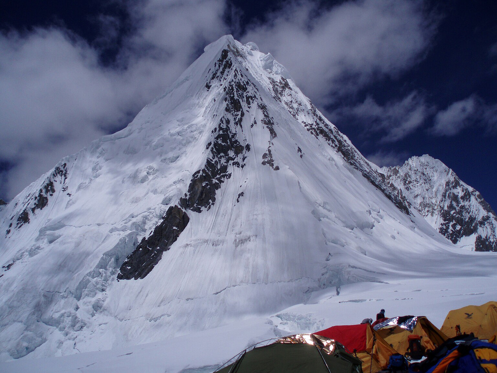
Shishapangma is located in south-central Tibet, a few kilometres from the border with Nepal. It is the only eight-thousander entirely within Chinese territory. It is also the highest peak in the Jugal Himal which is contiguous with and often considered part of Langtang Himal. The Jugal/Langtang Himal straddles the Tibet/Nepal border. Since Shishapangma is on the dry north side of the Himalayan crest and further from the lower terrain of Nepal, it has less dramatic vertical relief than most major Himalayan peaks.

Shishapangma the fourteenth highest of Eight thousanders Of Himalaya


Shishāpāngmā (also called Xixiabangma or Gosainthān) is the fourteenth-highest mountain in the world and, at 8,013 m (26,289 ft), the lowest of the eight-thousanders. It was the last 8,000 metre peak to be climbed, due to its location entirely within Tibet and the restrictions on visits by foreigners to the region imposed by Tibetan and Chinese authorities.


The Tibetan name shi sha sbang ma means "crest above the grassy plains". The Chinese name Xīxiàbāngmǎ Fēng is a phonetic rendition of the Tibetan name. In Sanskrit, the mountain is called Gosainthan, which means "place of the saint" or "Abode of God". Another interpretation, based on the spelling Shisha-Pangma, is that the name means, literally, "Sherpa Woman."


Timeline Climbing Of Gasherbrum II


  • 1956 First ascent
  • 1975 Second ascent by a French group, 19 years after the first ascent. This expedition also saw the first death on the Gasherbrum. Three other expeditions summit including a Polish women's team headed by Wanda Rutkiewicz.
  • 1979 A Chilean and a German expedition succeed in the sixth and seventh ascents. The Chilean was the first latinamerican ascent to an eight-thousander
  • 1982 Reinhold Messner reaches the top with two Pakistanis, Nazir Sabir and Sher Khan.
  • 1983 Jerzy Kukuczka with Wojciech Kurtyka eastern ridge ascent, new route. Alpine style ascent without the aid of oxygen.
  • 1984 Messner and Hans Kammerlander traverse Gasherbrum I and Gasherbrum II without returning to base camp in between.
  • 1984 First descent by ski by team CAF Besançon (France) led by Daniel Croisot, summit by Wim Pasquier and Patrice Bournat, ski from the summit, joined by Dr Dominique Dock from 7800m, totally skied the face down to base-camp set at 5200m. 1 month after meeting with Messner and Kammerlander, returning from their 2 summits.
  • 2005 Ski descent by Jørgen Aamot (Norway) and Frederik Ericsson (Sweden)
  • 2007 Three Italians, Karl Unterkircher, Daniele Bernasconi and Michele Compagnoni, reach the top opening a new way on the north face, in alpine style.
  • 2011 First winter ascent by Simone Moro, Denis Urubko and Cory Richards in alpine style.

Gasherbrum II the thirteenth highest of Eight thousanders Of Himalaya


Gasherbrum II (also known as K4) is the 13th highest mountain on Earth, located in the Gilgit Baltistan province, Pakistan near the border to China. Gasherbrum II is the third highest peak of the Gasherbrum massif, located in the Karakoram range of the Himalaya.

The standard climbing route is via the southwest ridge as it is relatively free of objective hazards such as ice falls and avalanches. A typical expedition lasts 7 to 8 weeks with climbing permits costing about US$7,500 for five climbers.


Gasherbrum II was first climbed on July 8, 1956 by Fritz Moravec, Josef Larch and Hans Willenpart of an Austrian expedition.

Climbing history Of Broad Peak


The first ascent of Broad Peak was made on June 9, 1957 by Fritz Wintersteller, Marcus Schmuck, Kurt Diemberger, and Hermann Buhl of an Austrian expedition led by Marcus Schmuck. A first attempt by the team was made on May 29 where Fritz Wintersteller and Kurt Diemberger reached the forepeak (8,030 m). This was also accomplished without the aid of supplemental oxygen or high altitude porters and without base camp support.

On the same expedition, Marcus Schmuck and Fritz Wintersteller made a flash first ascent of Skil Brum peak (7,360 m) on June 19, 1957 in pure Alpine style in 53 hours.


Hermann Buhl fell to his death when he and Diemberger attempted to climb nearby Chogolisa peak (7,654 m) on June 27, 1957.

The summit of Broad Peak has been descended on skis.

In July 2007 an Austrian mountaineering team climbed Broad Peak with the aim of retrieving the corpse of Markus Kronthaler, who had died on the mountain one year before, from over 8,000 metres.

In the winter and summer of 2009 there were no summits. There was one winter expedition by a Polish-Canadian team. In the summer there was one fatality, Cristina Castagna.

Time line
  • 1954 First attempt by Dr. Karl Herligkoffer of Germany on the SW side that failed due to a storm and extreme cold.
  • 1957 First ascent
  • 1994 On July 9, Carlos Carsolio got the summit establishing a new solo route, now known as Route Carsolio. The summit of Broad Peak would be the ninth of his career-high of eight-thousanders.


Broad Peak the twelfth highest of Eight thousanders Of Himalaya


Broad Peak (originally named K3), known locally as Faichan Kangri, is the 12th highest mountain on Earth, with an elevation of 8,051 meters (26,414 ft). The literal translation of "Broad Peak" to Phalchan Kangri is not accepted among the Balti people.


Geography

Broad Peak is part of the Gasherbrum massif on the border of Pakistan and China. It is located about 8 kilometres (5 miles) from K2. Broad Peak was originally named K3 right after the naming of K2 but on closer inspection by a later party, it was discovered that the summit was over 1.5 kilometres (1 mile) long, thus "Broad Peak".

Timeline Climbing Of Gasherbrum I


  • 1934 - A large international expedition, organized by the Swiss G.O. Dyhrenfurth, explores Gasherbrum I and II. Two climbers get to 6,300 m/20,650 ft.
  • 1936 - A French expedition gets to 6,900 m/22,630 ft.
  • 1958 - An American team makes the first ascent.
  • 1975 - Reinhold Messner and Peter Habeler reach the summit on a new route (northwest route) in pure alpine style (first time on an 8000 metre peak) taking 3 days total. One day later, three Austrians from a different expedition led by Hanns Schell reach the summit on the American route.
  • 1977 - The fourth successful ascent by two Slovenians (Nejc Zaplotnik and Andrej Stremfelj), again on a new route.
  • 1980 - A French expedition is successful with the 5th ascent and pass the south ridge for the first time.
  • 1981 - Japanese have the 6th successful ascent.
  • 1982 - G. Sturm, M. Dacher and S. Hupfauer of a German expedition summit via a new route on the north face. In the same year, French Marie-José Valençot is the first woman who reaches the summit. Her husband, Sylvain Saudan from Switzerland performs the first ski descent from the top of an 8000 metre peak to base camp.
  • 1983 - Jerzy Kukuczka with Wojciech Kurtyka, new route. Alpine style ascent without the aid of oxygen.
  • 1983 - Teams from Switzerland and Spain are successful.
  • 1984 - Reinhold Messner and Hans Kammerlander traverse Gasherbrum II and Gasherbrum I without returning to base camp in between
  • 1985 - Solo ascent by Benoît Chamoux.
  • 2003 - 19 people reach the summit, 4 deaths, including Mohammad Oraz.

Gasherbrum I the eleventh highest of Eight thousanders Of Himalaya


Gasherbrum I (also known as Hidden Peak or K5) is the 11th highest peak on Earth, located on the Pakistan-China border in Gilgit-Baltistan region of Pakistan. Gasherbrum I is part of the Gasherbrum massif, located in the Karakoram region of the Himalaya. Gasherbrum is often claimed to mean "Shining Wall", presumably a reference to the highly visible face of the neighboring peak Gasherbrum IV; but in fact it comes from "rgasha" (beautiful) + "brum" (mountain) in Balti, hence it actually means "beautiful mountain."


Gasherbrum I was designated K5 (meaning the 5th peak of the Karakoram) by T.G. Montgomery in 1856 when he first spotted the peaks of the Karakoram from more than 200 km away during the Great Trigonometric Survey of India. In 1892, William Martin Conway provided the alternate name, Hidden Peak, in reference to its extreme remoteness.

Gasherbrum I was first climbed on July 5, 1958 by Pete Schoening and Andy Kauffman of an eight-man American expedition led by Nicholas B. Clinch. Richard K. Irvin, Tom Nevison, Tom McCormack, Bob Swift and Gil Roberts were also members of the team.

Trekking Of Annapurna


The Annapurna Conservation Area is a well known trekking region.

There are three major trekking routes in the Annapurna region: the Jomson Trek to Jomsom and Muktinath (increasingly disturbed by a road-building project); the Annapurna Sanctuary route to Annapurna base camp; and the Annapurna Circuit, which circles the Annapurna Himal itself and includes the Jomsom route. The town of Pokhara usually serves as a starting point for these treks, and is also a good starting place for other short treks of one to four days, such as routes to Ghorepani or Ghandruk.

The Mustang district, a former kingdom bordering Tibet, is also geographically a part of the Annapurna region, but treks to upper Mustang are subject to special restrictions.


About two-thirds of all trekkers in Nepal visit the Annapurna region. The area is easily accessible, guesthouses in the hills are plentiful, and treks here offer incredibly diverse scenery, with both high mountains and lowland villages. Also, because the entire area is inhabited, trekking in the region offers unique cultural exposure and experience.

Climbing expeditions Of Annapurna


Annapurna I

Annapurna I was the first 8,000-metre (26,200 ft) peak to be climbed. Maurice Herzog and Louis Lachenal, of a French expedition led by Maurice Herzog (including Lionel Terray, Gaston Rébuffat, Marcel Ichac, Jean Couzy, Marcel Schatz, Jacques Oudot, Francis de Noyelle), reached the summit on 3 June 1950. (See the documentary of the expedition "Victoire sur l'Annapurna" by Marcel Ichac). Its summit was the highest summit attained on Earth for three years, until the first successful ascent of Mount Everest. (However, higher non-summit points—at least 8,500 metres (27,900 ft)—had already been attained on Everest in the 1920s.)

The south face of Annapurna was first climbed in 1970 by Don Whillans and Dougal Haston, members of a British expedition led by Chris Bonington which included the alpinist Ian Clough, who was killed by a falling serac during the descent. They were, however, beaten to the second ascent of Annapurna by a matter of days by a British Army expedition led by Henry Day.

In 1978, The American Women's Himalayan Expedition, a team led by Arlene Blum, became the first American team to climb Annapurna I. The first summit team, comprising Vera Komarkova and Irene Miller and Sherpas Mingma Tsering and Chewang Ringjing, reached the top at 3:30 p.m. on October 15, 1978. The second summit team, Alison Chadwick-Onyszkiewicz and Vera Watson, died during this climb.
On 3 February 1987, Polish climbers Jerzy Kukuczka and Artur Hajzer made the first winter ascent of Annapurna I.

Annapurna I holds the highest fatality rate among all 14 eight-thousanders. As of 2005, there have been only 103 successful summit attempts, and 56 lives have been lost on the mountain, many to the avalanches for which it is known. Climbers killed on the peak include famed Russian climber Anatoli Boukreev in 1997, Christian Kuntner in 2005 and Iñaki Ochoa in 2008.

The first solo climb was October 2007 on the South Face by Slovenian climber Tomaž Humar.

On April 27, 2010, Oh Eun-Sun, a South Korean climber, may have become the first woman to ascend the world's 14 highest mountains by climbing the Annapurna with no oxygen. However, her claim to have climbed all 14 is currently treated as disputed by influential record keeper Elizabeth Hawley pending further investigation.


The other peaks

Annapurna II, the eastern anchor of the range, was first climbed in 1960 by a British/Indian/Nepalese team led by Jimmy Roberts, via the West Ridge, approached from the north. The summit party comprised Richard Grant, Chris Bonington, and Sherpa Ang Nyima. In terms of elevation, isolation (distance to a higher summit, namely Annapurna I, 30.5 km/19.0 mi) and prominence (2,437 m/7,995 ft), Annapurna II does not rank far behind Annapurna I. It is a fully independent peak, despite the close association with Annapurna I which its name seems to imply.

Annapurna III was first climbed in 1961 by an Indian expedition led by Capt. Mohan Singh Kohli, via the Northeast Face. The summit party comprised Mohan Kohli, Sonam Gyatso, and Sonam Girmi.

Annapurna IV, near Annapurna II, was first climbed in 1955 by a German expedition led by Heinz Steinmetz, via the North Face and Northwest Ridge. The summit party comprised Steinmetz, Harald Biller, and Jürgen Wellenkamp.

Gangapurna was first climbed in 1965 by a German expedition led by Günther Hauser, via the East Ridge. The summit party comprised 11 members of the expedition.

Annapurna South (also known as Annapurna Dakshin, or Moditse) was first climbed in 1964 by a Japanese expedition, via the North Ridge. The summit party comprised S. Uyeo and Mingma Tsering.

Hiunchuli (6,441 m/21,126 ft) is a satellite peak extending east from Annapurna South, Hiunchuli was first climbed in 1971 by an expedition led by U.S. Peace Corps Volunteer Craig Anderson.

Machapuchare (6,993 m/22,943 ft) is another important peak of the Annapurna Himal, though it just misses the 7,000 metre mark. Machapuchare and Hiunchuli are prominently visible from the valley of Pokhara. These peaks are the "gates" to the Annapurna Sanctuary leading to the immense south face of Annapurna I.


Geography Of Annapurna

The Annapurna massif contains six major peaks over 7,200 m:

Annapurna From West

Annapurna I 8,091 m (26,545 ft) Ranked 10th; Prominence=2,984 m 28.595°N 83.819°E
Annapurna II 7,937 m (26,040 ft) Ranked 16th; Prominence=2,437 m 28.539°N 84.137°E
Annapurna III 7,555 m (24,786 ft) Ranked 42nd; Prominence=703 m 28.585°N 84.000°E
Annapurna IV 7,525 m (24,688 ft) 28.539°N 84.087°E
Gangapurna 7,455 m (24,457 ft) Ranked 59th; Prominence=563 m 28.606°N 83.965°E
Annapurna South 7,219 m (23,684 ft) Ranked 101st; Prominence=775 m 28.518°N 83.806°E

Friday, June 3, 2011

Annapurna the tenth highest of Eight thousanders Of Himalaya

Annapurna south face

Annapurna  is a section of the Himalaya in north-central Nepal that includes 8091 meter (26,545 ft) Annapurna I, thirteen additional peaks over 7000 meters and 16 more over 6000 meters. This section is a 55 km (34 mi)-long massif. Annapurna I is tenth among Earth's fourteen eight-thousanders. It rises east of the Kali Gandaki Gorge separating it from Dhaulagiri massif. 8167 meter Dhaulagiri I is 34 km to the west and the gorge between is considered Earth's deepest.

Annapurna is a Sanskrit name which literally means "full of food" (feminine form), but is normally translated as Goddess of the Harvests. In Hinduism, Annapurna is "the universal and timeless kitchen-goddess . . . the mother who feeds. Without her there is starvation, a universal fear: this makes Annapurna a universal goddess. . . . Her most popular shrine is located in Kashi, on the banks of the river Ganga." Her association with the giving of food (wealth) led her in time to be transformed into Lakshmi, the Goddess of Wealth.

The entire massif and surrounding area are protected within the 7,629 km2 Annapurna Conservation Area, the first and largest conservation area in Nepal, established in 1986 by the King Mahendra Trust for Nature Conservation. The Annapurna Conservation Area is home to several world-class treks, including the Annapurna Circuit.

The Annapurna peaks are the world's most dangerous mountains to climb. As of 2007, there had been 153 summit ascents of Annapurna I, and 58 climbing fatalities on the mountain. This fatality to summit ratio (38%) is the highest of any of the eight-thousanders.


Climbing history Of Nanga Parbat


Early attempts
Climbing attempts started very early on Nanga Parbat. In 1895 Albert F. Mummery led an expedition to the peak, and reached almost 7,000 m (23,000 ft) on the Diamir (West) Face, but Mummery and two Gurkha companions later died reconnoitering the Rakhiot Face.

In the 1930s, Nanga Parbat became the focus of German interest in the Himalaya. The German mountaineers were unable to attempt Mount Everest, as only the British had access to Tibet. Initially German efforts focussed on Kanchenjunga, to which Paul Bauer led two expeditions in 1930 and 1931, but with its long ridges and steep faces Kanchenjunga was more difficult than Everest and neither expedition made much progress. K2 was known to be harder still, and its remoteness meant that even reaching its base would be a major undertaking. Nanga Parbat was therefore the highest mountain accessible to Germans which they seemed to have a chance of climbing.

The first German expedition to Nanga Parbat was led by Willy Merkl in 1932. It is sometimes referred to as a German-American expedition, as the eight climbers included Rand Herron, an American, and Fritz Wiessner, who would become an American citizen the following year. While the team were all strong climbers, none had Himalayan experience, and poor planning (particularly an inadequate number of porters), coupled with bad weather, prevented the team progressing far beyond the Rakhiot Peak, reached by Peter Aschenbrenner and Herbert Kunigk, but they did establish the feasibility of a route via Rakhiot Peak and the main ridge.

Merkl led another expedition in 1934, which was better prepared and financed with the full backing of the new Nazi government. Early in the expedition Alfred Drexel died, probably of high altitude pulmonary edema. The Tyrolean climbers Peter Aschenbrenner and Erwin Schneider reached an estimated height of (7,895 m / 25,900 ft) on July 6, but were forced to return because of worsening weather. On July 7 they and 14 others were trapped by a ferocious storm at 7,480 m (24,540 ft). During the desperate retreat that followed, three famous German mountaineers, Uli Wieland, Willo Welzenbach and Merkl himself, and six Sherpas died of exhaustion, exposure and altitude sickness, and several more suffered severe frostbite. The last survivor to reach safety, Ang Tsering, did so having spent seven days battling through the storm. It has been said that the disaster, "for sheer protracted agony, has no parallel in climbing annals."

In 1937, Karl Wien led another expedition to the mountain, following the same route as Merkl's expeditions had done. Progress was made, but more slowly than before due to heavy snowfall. Some time around the 14th of June seven Germans and nine Sherpas, almost the entire team, were at Camp IV below Raikot Peak when it was overwhelmed by an avalanche. All sixteen men died instantly in what remains the worst single disaster to occur on an 8000 m peak.

The Germans returned in 1938 led by Paul Bauer, but the expedition was plagued by bad weather, and Bauer, mindful of the previous disasters, ordered the party down before the Silver Saddle was reached. The following year a small four man expedition, including Heinrich Harrer, explored the Diamir Face with the aim of finding an easier route. They concluded that the face was a viable route, but the Second World War intervened and the four men were interned in India. Harrer's escape and subsequent travels became the subject of his book Seven Years in Tibet.


First ascent

At 4,100 m (13,450 ft), near the Rakhiot Base Camp
View from Latbo village. For a sense of scale, notice a 4-man yellow tent, dwarfed by the peak, near the bottom right. Just above the tent is a large white building.

Nanga Parbat was first climbed on July 3, 1953 by Austrian climber Hermann Buhl, a member of a German-Austrian team. The expedition was organized by the half-brother of Willy Merkl, Karl Herrligkoffer from Munich, while the expedition leader was Peter Aschenbrenner from Innsbruck, who had participated in the 1932 and 1934 attempts. By the time of this expedition, 31 people had already died on the mountain. The final push for the summit was dramatic: Buhl continued alone, after his companions had turned back, and arrived at 7 p.m.; the climbing being harder and more time consuming than he had anticipated. His descent was slowed when he lost a crampon. Caught by darkness, he was forced to bivouac standing upright on a narrow ledge, holding a small handhold with one hand. Exhausted, he dozed occasionally, but managed to maintain his balance. He was also very fortunate to have a calm night, so he was not subjected to wind chill. He finally reached his high camp at 7 p.m. the next day, 40 hours after setting out. The ascent was made without oxygen, and Buhl is the only man to have made the first ascent of an 8000 m peak alone.

Subsequent attempts and ascents

The second ascent of Nanga Parbat was via the Diamir Face, in 1962, by Germans Toni Kinshofer, S. Löw, and A. Mannhardt. The route is now the "standard route" on the mountain. The Kinshofer route does not ascend the middle of the Diamir Face, which is threatened by avalanches from massive hanging glaciers. Instead it climbs a buttress on the left side of the face.

In 1970 the brothers Günther and Reinhold Messner reached the summit via a direct route on the huge, difficult Rupal Face; this was the third ascent of the mountain. Their descent was epic: they were unable to descend their ascent route, and instead made the first traverse of the mountain, going down the Diamir Face. Unfortunately Günther was killed in an avalanche on the Diamir. (Messner's account of this incident was disputed, and cast a further shadow over this achievement. In 2005 Günther's remains were found on the Diamir Face.)

In 1971 Ivan Fiala and Michael Orolin summited Nanga Parbat via Buhl's 1953 route while other expedition members climb the SE peak (7,600 m / 24,925 ft) above the Silbersattel and the foresummit (7,850 m / 25,760 ft) above the Bazhin Gap.

In 1978 Reinhold Messner returned to the Diamir Face and achieved the first completely solo ascent (i.e. always solo above Base Camp) of an 8,000 m peak.

In 1984 the French climber Lilliane Barrard became the first woman to climb Nanga Parbat, along with her husband Maurice Barrard.

In 1985, Jerzy Kukuczka, Zygmunt Heinrich, Slawomir Lobodzinski (all Polish) and Carlos Carsolio (Mexico) climbed a bold line up the Southeast Pillar (or Polish Spur) on the right-hand side of the Rupal Face, reaching the summit July 13.. It was Kukuczka's 9th 8000m summit.

Also in 1985, a Polish women's team climbed the peak via the 1962 German Diamir Face route. Wanda Rutkiewicz, Krystyna Palmowska and Anna Czerwinska reached the summit on July 15.

"Modern" superalpinism was brought to Nanga Parbat in 1988 with an unsuccessful attempt or two on the Rupal Face by Barry Blanchard, Mark Twight, Ward Robinson and Kevin Doyle.

Summer 2005 saw a resurgence of lightweight, alpine-style attempts on the Rupal Face:

- In August 2005, Pakistani military helicopters rescued renowned Slovenian mountaineer Tomaž Humar, who was stuck under a narrow ice ledge at 5,900 m (19,400 ft) for six days. It is believed to be one of the few successful rescues carried out at such high altitude.

- In September 2005, Vince Anderson and Steve House did an extremely lightweight, fast ascent of a new, direct route on the face, earning high praise from the climbing community.

On the 17th or 18 July 2006, José Antonio Delgado Sucre, an elite high altitude climber from Venezuela, died a few days after making the summit, where he was caught by bad weather for 6 days and was unable to make his way down. He was the only Venezuelan climber, and one of the few Latin Americans, to have reached the summit of five eight-thousanders. Part of the expedition and the rescue efforts at base camp were captured on video as José Antonio Delgado Sucre was the subject of a pilot for a mountaineering television series. Explorart Films, the production company, later developed the project into a feature documentary film called Beyond the Summit, which was scheduled to be released theatrically in South America in January 2008.

On July 15, 2008, Italian elite alpinist Karl Unterkircher fell into a crevasse during an attempt to open, with Walter Nones and Simon Kehrer, a new route to the top. Unterkircher died, but Simon Kehrer and Walter Nones were rescued by the Pakistani rescue team after many efforts.

On July 12, 2009, after reaching the top of Nanga Parbat, South Korean climber Go Mi-Young fell off a cliff on the descent in bad weather. In her race to be the first woman to climb the 14 of the worlds highest peaks (the Eight Thousanders).

Nanga Parbat has never been climbed in winter.

Layout of the mountain Nanga Parbat


The core of Nanga Parbat is a long ridge trending southwest-northeast. The ridge is an enormous bulk of ice and rock. It has three faces, Diamir face, Rakhiot and Rupal. The southwestern portion of this main ridge is known as the Mazeno Wall, and has a number of subsidiary peaks. In the other direction, the main ridge arcs northeast at Rakhiot Peak (7,070 m / 23,196 ft). The south/southeast side of the mountain is dominated by the massive Rupal Face, noted above. The north/northwest side of the mountain, leading to the Indus, is more complex. It is split into the Diamir (west) face and the Rakhiot (north) face by a long ridge. There are a number of subsidiary summits, including North Peak (7,816 m / 25,643 ft) some 3 km north of the main summit. Near the base of the Rupal Face is a beautiful glacial lake called Latbo, above a seasonal shepherds' village of the same name.

Nanga Parbat the ninth highest of Eight thousanders Of Himalaya


Nanga Parbat is the ninth highest mountain on Earth and among the eight-thousanders with a summit elevation of 8,126 meters (26,660 ft). Nanga Parbat translates to "Naked Mountain" in English; parbat deriving from the Sanskrit word parvata meaning "mountain, rock", and nanga from the Sanskrit nagna meaning "naked". Known as the "Killer Mountain", Nanga Parbat was one of the deadliest of the eight-thousanders for climbers in the first half of the twentieth century; since that time it has been less so, though still an extremely serious climb. It is also an immense, dramatic peak that rises far above its surrounding terrain.

Location

Nanga Parbat forms the western anchor of the Himalayan Range and is the westernmost eight-thousander. It lies just south of the Indus River in the Astore District of Gilgit-Baltistan in Pakistan administered Kashmir. Not far to the north is the western end of the Karakoram range


Notable features

Nanga Parbat has tremendous vertical relief over local terrain in all directions.

To the south, Nanga Parbat boasts what is often referred to as the highest mountain face in the world: the Rupal Face rises 4,600 m (15,000 ft) above its base. To the north, the complex, somewhat more gently sloped Rakhiot Flank rises 7,000 m (23,000 ft) from the Indus River valley to the summit in just 27 km (16.8 miles), one of the 10 greatest elevation gains in so short a distance on Earth.

Nanga Parbat is one of only two peaks on Earth that rank in the top twenty of both the highest mountains in the world, and the most prominent peaks in the world, ranking ninth and fourteenth respectively. The other being Mount Everest, which is first on both lists.

 
Design by | Bloggerized by World Mountain - Premium Blogger Themes | Blogger Templates